Natural places
There are enough beautiful natural places in Almaty region. We offer you the most picturesque places in the Almaty region.

Макеты усадьбы бабушки Айганым в Сырымбете, где прошло детство Чокана, надгробного сооружения на его могиле, оригинальный гобелен, вытканный руками современных мастериц и воспроизводящий маршрут знаменитых путешествий ученого, органично сливаются с экспонатами того времени.
В экспозиции представлены издания произведений Ч.Валиханова - прижизненные и посмертные. Огромное историческое значение научной и просветительской деятельности Ч.Валиханова осознается в наши дни глубже и полнее, чем когда-либо.
Много сделано по увековечению его творческого наследия, пропаганде его научных трудов. Именем великого ученого названы институт при Национальной Академии наук РК, район в Кокчетаве, улицы в городах Казахстана, сооружены памятники в областях, городах, районах страны.
Также можно подняться к мемориалу Чокана Валиханова, откуда хорошо просматривается аул «Шокан». Посетить могилу Чокана Валиханова, на которой установлена стела с изображением его лика смотрящего в вечность и увенчанного земным шаром. Там же вмонтирована надгробная плита, изготовлена и привезена из Екатеринбурга стараниями Константина Кауфмана в 1881 году, на которой высечено «Здесь покоится прах штабс-ротмистра Чокана Чингисовича Валиханова, скончавшегося 1865 году. По желанию Туркестанского генерал-губернатора Кауфмана, во внимание учёных заслуг Валиханова, положен, сей памятник генерал лейтенантом Колпаковским».
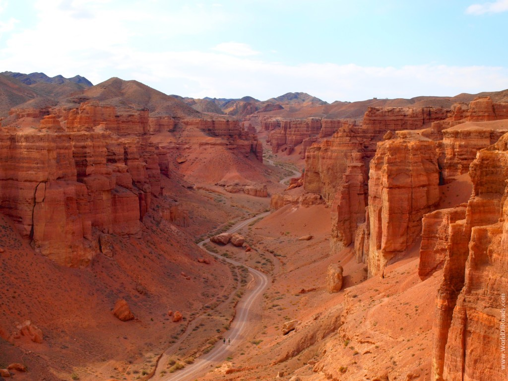
Charyn canyon
Charyn canyon is a 154 km long canyon along the Charyn river in Kazakhstan. The canyon is located 195 km East of Almaty, near the border with China. It is located on the territory of three districts of Almaty region: Uyghur, Raiymbek, Enbekshikazakh. The canyon is part of the Charyn national Park, established on February 23, 2004. The Charyn canyon is a natural monument made up of sedimentary rocks that are about 12 million years old. The height of the steep mountains of the canyon reaches 150-300 m.
According to Professor P. I. Marikovsky, the canyon was formed about 25 million years ago in the tertiary period, when there was a large lake at this place. Slopes are formed both as a result of rock destruction (denudation) and as a result of rock deposition (marl — white calcareous rocks).
Valley of castles
Red canyon or Valley of castles is a dry gorge, washed out by melt water. It is located perpendicular to the Sharyn river, which flows through clay-sand mountains and stone cliffs. The red canyon is about 3 km long, 20 to 130 m wide, and 100 m deep.
The most interesting place for tourists is the so-called valley of castles, which is about 2 km long and 20-80 m wide. In this area of Central Asia were: N. Severtsova, A. N. Krasnova, Chokan Valikhanov.
The Charyn canyon is a natural monument made up of sedimentary rocks that are about 12 million years old.
Its territory is protected by 34 species of animals and plants listed in the Red book, as well as home to more than 60 species of mammals, 300 species of birds, 20 species of amphibians and 800 species of arthropods.
Charyn canyon is considered to be the younger brother of the Grand Canyon of the USA and is also deservedly often compared with it. The natural dimensions of this grandiose creation of nature are, in terms of length 200 km and in terms of height from 100 to more than 300 meters. The best option when choosing a country holiday in Almaty is an excursion to the Charyn canyon. Getting to this amazing place is easy: 200 km from Almaty in the East is the Charyn river. It is there that the Charyn canyon awaits its guests.
Charyn canyon is an extremely beautiful place. Its walls often consist of large deposits of clay, which at sunset turns red, and shimmers with amazing shades. If you look long and closely at the clay base of the canyon, you can "see" the whole ancient city, which seems to come to life under the rays of the setting sun. In the canyon, time and natural factors have made countless grottos, caves, and huge cracks, as if they painted the entire canyon.
The area around the canyon, with poplars, tamarisk and reeds growing everywhere, is identical to the unexplored desert area. Near the canyon, a river flows, bringing anyone who looks here, the cool air of the mountains. Here, in the valley of the Charyn river near the canyon, the famous ash grove is located, the territory of which is more than 200 km. A huge amount of time passed, epochs changed, old plants and animals disappeared and new ones appeared, and the ash grove itself remained the same as it was dozens of centuries ago.
The Charyn river itself, which gives names to the canyon, starts from the foothills of the TRANS-ili Alatau and flows into the Ili. The long existence of the river led to the appearance of the canyon-the twin brother of the Grand Canyon in Colorado, slightly smaller in size, but equal to it, and perhaps even better, in beauty.
The Charyn canyon itself is a huge chasm with a depth of more than 200 meters.
Its geological age is more than 30 million years. Another unique feature of the canyon is its landscape, there are only a few such types of land surface in the world.
When to go
Tourists are advised to go to the Charyn canyon in spring (late March and early may) and autumn (late August – early November).
In summer, hot weather can prevent you from enjoying the beauty of the region. In June and July, the thermometer rises to 36 degrees Celsius. In winter, the flow of tourists is noticeably reduced. At this time of year, the average air temperature in Charyn is six degrees below zero.
What to take with you
Before visiting the Charyn Canyon, you must buy water and food. Despite the fact that there are cafes on the territory of the gorge, establishments may not work daily.
The following items from the list are also recommended to take with
you
1) Sunglasses
2) Sunscreen
3) Hat or cap
4) Sneakers
5) Camera
Tips for tourists:
Take with you: Comfortable clothes and shoes, a headdress, 1 liter of water per person, optional food, ID card or passport required!
Flora and fauna
The landscape diversity of the Charyn canyon determines the diversity of flora and fauna. There are more than 1,500 species of plants, 17 of which are listed in the Red book of Kazakhstan and 62 species of mammals, 103 species of nesting birds, 25 species of reptiles.
The landscape diversity of the Charyn canyon determines the diversity of flora and fauna. There are more than 1,500 species of plants, 17 of which are listed in the Red book of Kazakhstan and 62 species of mammals, 103 species of nesting birds, 25 species of reptiles.


Kolsay Lake
A popular place in the Almaty region is the freshwater Kolsay lakes, which are located within the Northern Tien Shan.
Kolsai lakes (Kulsai) — a system of three lakes in the Northern Tien Shan, in the Kolsai gorge, in the bridge connecting the Kungei-Alatau and Zailiysky Alatau ranges. The lakes are located on the territory of the Raiymbek district of the Almaty region of Kazakhstan and are located 10 km North of the border with Kyrgyzstan, 330 km South-East of Alma-ATA at an altitude of about 1000 m, 2500 m, 2700 m above sea level.
The lakes are called the "pearl of the Northern Tien Shan". The lakes are surrounded by a coniferous forest of Tien Shan spruce. The depth of the lakes reaches 50 m. Among the fauna — rainbow trout.
Kolsay lakes include 3 lakes:
1) The third lake is located at an altitude of 1818 m, its length is 1 km, width is 400 m, depth is 80 m •
2) Secondary (second) Kolsay lake (Mynzhylgy) - located at an altitude of 2252, the largest of the three lakes.
3) The first Kolsai lake or Upper Kolsai - at an altitude of 2850 m.
11 km to the East of the village of Saty is the picturesque lake Kaindy.
Tourism
Kolsay lakes are located on the territory of the national Park "Kolsay kolderi" and are a tourist attraction. Guest houses and campsites are located nearby. In Soviet times, there was a 25 km long tourist route that included visiting all three Kolsai lakes, as well as the Sary-Bulak pass and descending to Issyk-Kul lake. As of 2017, the pass is closed, visiting the Upper Kolsay lake without a border pass is impossible .
From the Kazakh language, the single name "Kolsay "can be translated as" lake in the gorge", because all reservoirs belong to the natural depression of the same name. Kolsay lakes are on the territory of national Park "Kolsai lakes" in the Almaty region.
They are called the "blue necklace" for the surprisingly clear water, on the surface of which the boundless blue sky is reflected. The system of Kolsay reservoirs includes three lakes: Upper, Middle and Lower-all of them are quite deep, cool and very, very beautiful. Trekking routes, horse excursions and walks are organized here.
Useful tips for 2020-2021
Food and overnight stay
In the village of Saty, you can stay in comfortable and authentic guest houses, try national dishes prepared by the owners of the houses, and enjoy the leisurely life of the Kazakh village. It is better to book your accommodation in advance through travel agencies. In the warm season, without an agreement, all houses can be occupied. Meals are usually included in the accommodation of the place where you stay, there are no separate cafes here.
You can also stay in hotels directly near the first Kolsay lake. And you can equip a tent city. Then it is better to stock up on food in Almaty.
Please familiarize yourself with the tariffs for services provided by national natural Park "Kolsai lakes".
A trip to the Kolsay lakes can be combined with a visit to lake kayyndy.
Advice for foreign visitors
Despite the fact that the Kolsay lakes and lake kayyndy are located in the border area that is part of the border zone, no passes are required to visit them, since the lakes are included in the list of territories where certain regime restrictions are excluded or suspended.
However, it is necessary to have identity documents with you, including for Kazakhstanis.


The Singing Dune
Singing dune is a mountain of light-colored sand, has a length of up to 3 km and a height of 150 m. Barkhan is located in the corridor between the ridges of the Dzungarian Alatau-Big and Small kalkans on the territory of the Altyn-Emel national Park in the Almaty region of Kazakhstan, 183 km northeast of Alma-ATA. The singing dune is a natural phenomenon, famous for the fact that in dry weather the Sands emit a sound similar to the melody of a ringing organ.
The sand created by the Singing dune arises from the sandbanks of the Ili river. In both directions, the river stretches peculiar tails of the dune, which can be seen with the naked eye. Stratifications are formed due to the fact that the Large and Small kalkans, standing at a slight angle to each other, sand, driven by the winds, hits the stone ridge, thereby settling. For many centuries and centuries, a powerful sand mountain has risen, which remains motionless for about 3-5 thousand years. The height of the dune depends on the climate, which, as is known in that area, varies greatly and constantly, as well as on the amount of precipitation, the water level in the Ili river and the exposure of shoals subject to inflating.
Tourist attraction
The dune offers a beautiful view of the surrounding area. In the South, a thin strip of ili river, violet mountains Sogety and Boguty, for which we observe white tops of Ketmen ridges. From the West, the horizon is covered by the steep side of the Big Kalkan, from the East — by the Small one. And in the North, behind it, you can see the lilac-blue ridge of the Jungar Alatau spurs, the Chulak, Matai and Altyn-Emel mountains. At their foot is a low-lying valley, cut by thin strips of dry channels of rain streams. The South-Western slope of the dune is smooth, while the opposite one in the North-East has several ridges with gentle slopes. The singing dune is a popular tourist attraction.
Emergence
The dune was formed as a result of blowing sand from the shallows of the Ili river. In this part of the Ili river valley (between the Alans and the Bogaty and Syugaty mountains), a strong wind blows, which raises clouds of sand dust from the riverbanks. At the Big and Small kalkans, standing at a slight angle to each other, the wind meets an obstacle and, having weakened, leaves sand. So, for many thousands of years, grew up a huge pile of sand. The dune does not roam the plain, despite the fluctuation of sand and strong winds, but remains in place for several millennia.
Legends
Singing Sands from ancient times caused a lot of popular superstitions. In the legends that have come down to our days, the singing of the Sands was explained by the activity of desert spirits, fantastic animals, the sound of the bells of buried cities, powerful rivers raging underground, and many other unusual reasons.
One of the legends says: "In ancient times, Shaitan (i.e., the devil) traveled the world. Spying on people, plotting, keeping up with everything and not missing anything. Once the Almighty was angry with him and made it impossible to move from one place to another with lightning speed. Then Shaitan had to walk to his house — and the house was on the top of a mountain. For a long time Shaitan walked on the steppe, made his way along the winding paths along the banks of the river Or, finally tired and lay down to rest. So difficult was his path and so heavy was the burden of his deeds that Shaitan fell into a deep sleep. And he still sleeps, turned into a lonely dune, and nothing and no one can Wake him — no scorching sun, no rain, no thunderstorms, no winds. Only sometimes a lonely moan escapes from his chest when someone tries to disturb the forever asleep Shaitan."
According to another legend, Genghis Khan and his military associates are buried under the Sands of the dune, and the sand sings when the Khan's soul is "exhausted from mental torment, tells descendants about his exploits."

Tips for tourists:
Take with you: Comfortable clothes and shoes, headdress, water 1 liter per person, optional food, ID card or passport required!
How to dress: headwear, windbreaker or jacket, comfortable walking shoes (do not wear slates or flip-flops), sports closed trousers.
Take with you: Comfortable clothes and shoes, headdress, water 1 liter per person, optional food, ID card or passport required!
How to dress: headwear, windbreaker or jacket, comfortable walking shoes (do not wear slates or flip-flops), sports closed trousers.
Butakovsky waterfall
Butakovsky waterfall is one of the most beautiful places in the Alatau. It is located in the Butakovsky gorge and is one of the most famous and visited natural sites near Almaty. There are different ways to get to it.
This waterfall is formed by a stream that falls almost vertically down along the cliff. A little above the top of the waterfall, the stream water is lost under rocks. The stream is full-flowing throughout its entire length, obviously, during the spring snowmelt. I once went through the entire riverbed in July from the beginning to the place where the waterfall was formed. Water appeared from under the rocks only near the waterfall. What is the height of this waterfall? On the Board on the way to Komissarovsky pass, the route description indicates 15 m. The book "Mountain trails of Almaty" says about 30 m. Visually, butakovsky waterfall is more than 15 m and, obviously, 30 m-closer to the exact figure. Water first falls on a ledge (stage), which can be considered as a cascade. It is believed that if all the steps of a vertical fall fit into an angle of 45 degrees, then this is a cascade of one waterfall.if it is more than 45 degrees, then we must talk about several waterfalls. In the case of Butakovsky waterfall, this angle is less than 45. In order to make the scale of the waterfall visible, the photo gallery contains a picture with a person next to it (the height of the person is 1 m 76 cm). There are no problems with drinking water on this route. Water can be collected in a container from a stream along the road/trail to Komissarovsky pass. Halfway from the pass to Butakovsky gorge, the trail crosses a stream. On the way up in the Butakovsky gorge, the river is always nearby. There are also springs that flow down the right slope (if you turn your face to the South). Very tasty water in the stream running directly from the waterfall. The described waterfall is not the only one in the Butakovsky gorge. Upstream of Butakovka there is another waterfall, which is about 1.5 hours away. Located on the Western slope of the gorge (that is, on the right, if you go up the gorge). It can be seen from a certain point on the trail when descending from the Butakovsky pass to the Butakovsky gorge. The most comfortable place for a picnic after visiting Butakovsky waterfall is in a clearing 100 m South of the private recreation area. It is necessary to go from the bathhouse on the Bank of an artificial dam, 50 m along the river up, cross it over the bridge (or over the stones, if you do not find the bridge) and climb to the hillock on the opposite Bank. You will find yourself in a fairly spacious clearing surrounded by fir trees. In the center of the clearing is a hearth of stones. During the trip/hike, do not leave garbage in the mountains (bags, bottles, paper, etc. d.) and, if possible, dispose of garbage left by other "Lovers" of the mountains.
This waterfall is formed by a stream that falls almost vertically down along the cliff. A little above the top of the waterfall, the stream water is lost under rocks. The stream is full-flowing throughout its entire length, obviously, during the spring snowmelt. I once went through the entire riverbed in July from the beginning to the place where the waterfall was formed. Water appeared from under the rocks only near the waterfall. What is the height of this waterfall? On the Board on the way to Komissarovsky pass, the route description indicates 15 m. The book "Mountain trails of Almaty" says about 30 m. Visually, butakovsky waterfall is more than 15 m and, obviously, 30 m-closer to the exact figure. Water first falls on a ledge (stage), which can be considered as a cascade. It is believed that if all the steps of a vertical fall fit into an angle of 45 degrees, then this is a cascade of one waterfall.if it is more than 45 degrees, then we must talk about several waterfalls. In the case of Butakovsky waterfall, this angle is less than 45. In order to make the scale of the waterfall visible, the photo gallery contains a picture with a person next to it (the height of the person is 1 m 76 cm). There are no problems with drinking water on this route. Water can be collected in a container from a stream along the road/trail to Komissarovsky pass. Halfway from the pass to Butakovsky gorge, the trail crosses a stream. On the way up in the Butakovsky gorge, the river is always nearby. There are also springs that flow down the right slope (if you turn your face to the South). Very tasty water in the stream running directly from the waterfall. The described waterfall is not the only one in the Butakovsky gorge. Upstream of Butakovka there is another waterfall, which is about 1.5 hours away. Located on the Western slope of the gorge (that is, on the right, if you go up the gorge). It can be seen from a certain point on the trail when descending from the Butakovsky pass to the Butakovsky gorge. The most comfortable place for a picnic after visiting Butakovsky waterfall is in a clearing 100 m South of the private recreation area. It is necessary to go from the bathhouse on the Bank of an artificial dam, 50 m along the river up, cross it over the bridge (or over the stones, if you do not find the bridge) and climb to the hillock on the opposite Bank. You will find yourself in a fairly spacious clearing surrounded by fir trees. In the center of the clearing is a hearth of stones. During the trip/hike, do not leave garbage in the mountains (bags, bottles, paper, etc. d.) and, if possible, dispose of garbage left by other "Lovers" of the mountains.
Recommendations for clothing and equipment:
Taking into account the fact that it can be quite cold in the evenings and at night, take with you:
1. Waterproof membrane jacket/windbreaker, trousers made of gortex material
2. Windproof jacket, warm fleece jacket or jacket made of Polartec material
3. Several sets of underwear, several pairs of socks, one warm socks
4. Several t-shirts with short and long sleeves, shorts, cap
5. Good high-altitude trekking boots, a change of shoes for the camp, light sneakers are best
6. Headlamp, several sets of batteries
7. Thermos for 1-1. 5 liters, or other water container
8. Personal hygiene items personal first aid kit, sunglasses, sunscreen, a remedy for mites

Turgen Gorge
The Rocky Waterfall
The most inaccessible waterfall, so this waterfall is recommended to go to people who have sufficient physical training.
The most inaccessible waterfall, so this waterfall is recommended to go to people who have sufficient physical training.
Turgen Gorge is one of the outstanding features of the Ili-Alatau national Park. It is located very close to the center of Almaty, 70 km away, if you move East. The journey takes 5-6 hours, either by car or by mountain bike.
What can a tour to the Turgen gorge offer its guests?
In the gorge you will find thermal health springs, the opportunity to enjoy trout fishing, unique waterfalls and forest expanses. In the gorge of the forest there are many different coniferous and deciduous trees, Alpine and subalpine meadow fields, lakes, springs. All those interested in traditional medicine will receive a pleasant surprise in the form of various medicinal plants.
During the tour of the Turgen gorge, you can rent horses and ride through the vast loess lands of the Turgen gorge. So renting a horse can be very convenient to get to and watch the Turgenev waterfalls, of which there are only seven. The most large of them is the waterfall and the waterfall of bozgul. Bozgul with its powerful streams washed out a whole tunnel in the rock, which now attracts many people who want to see it with their own eyes.
On the way to the gorge, the stop "Ostrich farm" is expected - an interesting and very informative excursion. Turgen waterfalls .All three waterfalls are different and the height, beauty and accessibility. In General, there are only seven waterfalls in this gorge, but only three of them are popular.
Waterfall "Medvezhiy"
The drop height is 40 m. This is the most easily accessible and pleasant waterfall, and many tourists rest near it.
Saka mounds
Famous Saka mounds Dating back to 1 thousand BC.
Kiely-Bulak
Spring Legend says about the rejuvenating properties of water from the spring. Perhaps, having drunk crystal clear, tasty, cold water from the "source of eternal youth" You will not become younger in face, but in soul that's for sure.
Tips for tourists:
The routes to the waterfalls can not be called very difficult, but they are still mountain routes. This means that when going on the road, you need to take care of the appropriate shoes (they must have a firm sole, do not slip) and clothing in case of rain (windbreaker jacket or raincoat). A warm jacket or pullover will not be superfluous.
Do not forget about drinking water and a small amount of provisions (by the way, along the road and near the waterfalls themselves, there are many places where you can stop for a snack and relax - including specially equipped gazebos, yurts and just platforms with tables). You don't need to take a lot of water with you. Along the way, there are many springs with clear water.


Kairak Waterfall (Buzgul)
The drop height is more than 55 m. From the starting point to the waterfall about 9 km along a good dirt road in the midst of a picturesque forest. The entire walking route, including stops, will take approximately 5 hours. But if you spend your energy on this path, you will be rewarded with a magnificent view of this waterfall. It has a very powerful and rapid stream that made a tunnel in the rock.
The drop height is more than 55 m. From the starting point to the waterfall about 9 km along a good dirt road in the midst of a picturesque forest. The entire walking route, including stops, will take approximately 5 hours. But if you spend your energy on this path, you will be rewarded with a magnificent view of this waterfall. It has a very powerful and rapid stream that made a tunnel in the rock.

