Historical places
In the Almaty region, each sacred place has its own history and its own specifics.We offer you historical places of Almaty region.

Tamgaly tas
Tamgaly-Tas ("stones with signs/written stones") is a tract near the Ili river 120 km North of the city of Alma-ATA, where many petroglyphs, images of mysterious deities, and late Buddhist inscriptions have been preserved on the rocks. Among the petroglyphs, there are about a thousand rock images, among which the most famous are the images of Shakyamuni Buddha, Amitabha Buddha of Infinite Light and Avalokiteshvara bodhisattva of Infinite Compassion. In addition to Buddhist drawings and inscriptions, there is a stone with ancient Turkic runic writings of the VIII-IX centuries, presumably left by the Kipchaks. Tamgaly-TAS is protected by the government of Kazakhstan as a cultural monument and is an open-air Buddhist temple, as evidenced by a sign at the entrance to the tract. There is a legend that in the X century, when one of the Buddhist missions stopped on the Bank of the river Or during a trip to Semirechye, an earthquake occurred and a large piece of rock fell to the ground, which was regarded as a sign of the need to return to India.They had carved three images of the Buddha on a broken piece of rock.Scientists have solved the riddle of all the runes on it, it says that in 2004, on March 6, a prophet will be born. Other images of him can be found on the surrounding rocks, where pikey was killed.
According to another version, the inscriptions were made by Kalmyks on "todorkhoy nomyn bichig" ("clear literary writing"), which was created by Zaya Pandita Ogtorguin in 1648 and was used for more than three centuries by nomadic Mongols who carved images of the Buddha.
Stone research in Tamgaly-TAS began in the late XIX century. In 1875, Chokan Valikhanov made sketches of the area, and in 1899, the Mongol scholar Alexey Pozdneev gave a detailed description of the inscriptions and drawings in the Notes of the Russian geographical society
Close-up image of the Buddha, clearly visible damage, heard that some barbarian even shot at him with a gun. A true follower of the Taliban cause in Afghanistan, where these vandals blew up Buddha statues carved into the rocks. By the way, Japanese and Western scientists are now restoring them.
Admired work of the ancient master, it is not easy to take and daub with a can of paint - "Semey" or " here was Daniyar ". When Shokan Valikhanov drew images of Buddhas in the 19th century, the long crack on the left was already visible, but there were no other injuries yet
If you go further along the rocks, you can see many more unsophisticated images of animals and people. They were probably left by simple nomads. In General, it is quite an exciting activity to climb along the rocks and look for more and more new rock paintings and inscriptions.

Tamgaly tas tract, which means "Stones with signs" in Kazakh


Of course, petroglyphs, inscriptions and drawings are not as old as the same ancient Egyptian ones or in the South of France, but for Kazakhstan, where there are not so many ancient monuments, this is a very interesting and valuable phenomenon.
A hunter with a bow, apparently hunting a Buffalo.
A hunter with a bow, apparently hunting a Buffalo.

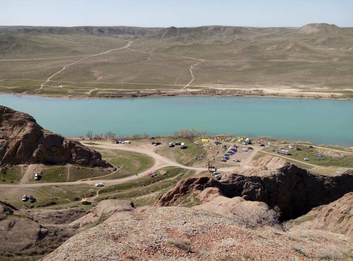
The ancients left us wonderful historical monuments, and our contemporaries-mountains of garbage on the shore of Ili. Tamgaly Tas is a very picturesque place and it is not for nothing that people of the past chose it for their rock galleries. Just beautiful are the rocks, the steppe that is beginning to turn green, the hills on the opposite Bank, and of course, the beauty or slowly rolling its transparent, blue waters!

It is necessary to climb the Written rock, 502 meters high. The height difference from the river Bank is about 70 meters, but the views are even more beautiful! You need to go up, skirting the rocks on the left. The ascent is not very steep and runs mainly on scree, so it is desirable to wear snickers

There are many places where you can put up tents. You can sit right on the river Bank, next to gazebos. It is also a very convenient place for bivouac — the gorge, to the left of the gate, there are many smooth comfortable areas. If you want to build a fire in the evening, it is better to bring firewood with you, it is convenient to cook food on gas. The rocks of this small gorge were chosen by rock climbers, their figures are visible in this photo, and our little red Nissan "beetle"is also visible.


On this gorge, going up the road that turns into a trail, you will see a small cave.
Here they left their writings and characters of our contemporaries. There is also a Buddhist right-wing swastika.
After visiting the written rocks, you should definitely go to the "Ancient city" - the scenery built in 2004 for the filming of the film "Nomad". To do this, you need to drive another 2.7 km along the road along the left Bank of the river. After the filming of" Nomad", episodes of several other films were shot here, so the city is maintained in good condition. To reach it, you need to turn to the village of Kazakhstan and after another 20-21 km turn right, towards the left Bank Ile lake .
After visiting the written rocks, you should definitely go to the "Ancient city" - the scenery built in 2004 for the filming of the film "Nomad". To do this, you need to drive another 2.7 km along the road along the left Bank of the river. After the filming of" Nomad", episodes of several other films were shot here, so the city is maintained in good condition. To reach it, you need to turn to the village of Kazakhstan and after another 20-21 km turn right, towards the left Bank Ile lake .

What else can you do in the tract?
Of course, trekking, there are many paths trampled around. You can climb on safe rocks, climb other hills adjacent to Ili. For example, alpinists found the highest point of the gorge in this place — 607 meters above sea level.
In the background, the Hanging stone rock, alpinists named it among ourselves — mount Tyubiteyka. Instability of the "skullcap" at the top, apparent. This stone lies very firmly on the top of the mountain.

View from the Hanging rock, the height is higher than at the top of the Written rock.
Tamgaly tas tract-attracts thousands of tourists, fishermen, rock climbers. The annual bard song festival is held here in may. It is good to come here with a tent and spend the night on the beach Or near the mysterious rock paintings and inscriptions. This is a place where you rest your soul. So drawn to go there again! I want to come, and even just sit down and watch, and look into the blue distance.
Tips for tourists:
Clothing recommendations
For comfortable trekking, you need clothing that does not restrict movement-trousers and a jacket. On the feet should be shoes without high heels, which is convenient to go on the trail: Hiking trekking boots or similar, with a good sole and high lacing, or sneakers. It is also advisable to bring warm clothes, warmer than you usually wear, in the cold season - a hat and gloves. Water tank or thermos with hot tea. Don't forget your sunglasses
Museum of Chokan Valikhanov “Altynemel”
History of the Museum
To the 150th anniversary of the birth of CH.The state memorial Museum “Altynemel”was opened for Valikhanov. This unique structure was designed by architects A. Seidalin, B. Ibraev, S. Rustambekov. The unusual appearance of the building, outwardly strict and concise, is harmoniously combined with the Museum exposition, which comprehensively reveals the life and scientific activities of CH.Valikhanov.
The architecture of the Museum is imbued with a kind of symbolism of the national epic and reflects the traditions of Kazakh memorial structures such as Mazar with clearly defined corner elements, which are associated in the ancient beliefs of the Kazakhs with the four corners of the universe. All the corners of the building are different in size, in the center of the lowered beams, passing into the so-called “knot of happiness”, woven from colored cords. According to popular legends, all levels of the world are connected in the center of the world. The mythical "seven layers of the earth" corresponds to the terraced floor of the Museum, built in such a way that the visitor gradually ascends the mountain in a spiral around the Central axis.
The interior design of the Museum resembles a Yurt-a traditional portable dwelling of nomadic pastoralists. It uses the coloristic composition that has developed in the aesthetic culture of the Kazakhs. The walls are red, for this was the traditional color of the dwellings, and the black-and-red floor corresponds to the idea of the underworld. White alabaster plaster ceiling, as if floating at different heights, reflects the ancient technique of decorating buildings. The lighting system, which gives an even upper light at any position of the sun, promotes the use of the entire space of the room for exposure. The facade of the building is decorated with Mangyshlak limestone, a soft, pliable pink stone.
The exposition consists of several sections related to the life and activities of CH.Valikhanov.
These are:
1) Materials that recreate a picture of the political, social and cultural life of the beginning. XIX century, which influenced the formation of Chokan's personality;
2) Materials telling about the years of study in the Omsk cadet corps and the beginning of official activity, meeting with representatives of the Russian intelligentsia;
3) The scientific legacy of Chokan Valikhanov, who left a deep mark on the study of the history, Ethnography, geography of Central, Central Asia, southern Siberia and Kazakhstan;
4) Materials about the Petersburg period, friendly and business relations with scientific and literary circles in Russia;
5) CH. Valikhanov in literature, painting and cinema.
The exposition starts with a granite bust of CH. Valikhanov, made by the people's artist of Kazakhstan H. Nauryzbayev. There are stone statues at the entrance to the Museum.


Models of the estate of grandmother Aiganym in Syrymbet, where Chokan spent his childhood, the tombstone on his grave, the original tapestry, woven by the hands of modern craftsmen and reproducing the route of the famous travels of the scientist, organically merge with the exhibits of that time.
The exhibition presents editions of works by CH.Valikhanov - lifetime and posthumous. The great historical significance of the scientific and educational activities of CH.Valikhanov is now more deeply and fully realized than ever.
Much has been done to perpetuate his creative legacy and promote his scientific works. The name of the great scientist Bose Institute at the National Academy of Sciences of Kazakhstan, the Kokchetav district, the streets in the cities of Kazakhstan, erected monuments in regions, cities and districts of the country.
You can also go up to the memorial of Chokan Valikhanov, from where you can clearly see the village "Shokan". Visit the grave of Chokan Valikhanov, which has a stele with the image of his face looking into eternity and crowned with a globe. There is also a tombstone, made and brought from Yekaterinburg by the efforts of Konstantin Kaufman in 1881, on which is carved "here lies the ashes of staff captain Chokan chingisovich Valikhanov, who died in 1865. At the request of the Turkestan Governor-General Kaufman, taking into account the scientific merits of Valikhanov, this monument was laid by Lieutenant-General Kolpakovsky."

Chokan Valikhanov
The name of the outstanding Kazakh scientist, educator-Democrat, ethnographer and folklorist Chokan chingisovich Valikhanov rightfully occupies an honorable place in the history of culture and social and scientific thought in Kazakhstan. One of the first among his compatriots, he initiated the spread of progressive ideas in the Kazakh steppes about the benefits of knowledge, the need for education for the people, and played a beneficial role in strengthening the friendship of the Russian and Kazakh peoples.
Chokan Valikhanov left behind an extensive scientific legacy. He managed to write a number of important works on the history, geography and Ethnography of the peoples of Central Asia and Kazakhstan. "Like a brilliant meteor, Chokan chingisovich Valikhanov flashed over the field of Oriental studies..." - wrote the famous Russian archaeologist and orientalist N. I. Veselovsky.
Scientific achievements of CH. Valikhanov as a researcher of Central Asia, Kazakhstan and East Turkestan were appreciated by the world science. His works were published in Russian, English, German and French.
The last years of his short but bright life of Shokan Valikhanov was held in Zhetysu. Here, in the Kochen-Togan tract, he died in April 1865, before reaching the age of thirty. Near the foot of the ridge Altaitelecom his ashes are buried.
The Museum is open daily, seven days a week. As part of the tour, the Museum staff can show the road leading to the burial place of the great scientist.
Koylyk
Koylyk (KAZ. Koylyk (until 1993 — Antonovka) is a village in the Sarkandsky district of the Almaty region of Kazakhstan. It is the administrative center and the only locality in Koilyk rural district.
It is located in the Northern foothills of the Dzungarian range, 45 km northeast of Samarkand.
The Site Of Kayalyk (Antonovsky)
Near the village is the site of Kayalyk (Antonovsky).
In the VIII—XIV centuries, the largest trade, craft and cultural center in the North-East of Semirechye, the headquarters of the Karluk jabgu.
The territory is surrounded by a fortress wall up to 4 m high. The plan is an irregular quadrilateral. The North-Eastern wall has a length of 1200 m, the South-Western wall is 750 m, adjacent to the foot of the mountains.
The city was famous for its bazaars, and in addition to Muslims, there were Christians who had their own Church. This is reported by William Rubruk, Ambassador of the French king Louis IX to the Mongol Khan Munke, who visited the city.
Archaeological research on the site was conducted in 1964. Since 1998, the annual excavations conducted by the expedition of the Institute of archeology named after A. H. Margulan, under the leadership of academician K. M. Baypakov.
Buddhist and Manichaean temples, objects of Muslim culture of the XII—XIV centuries were excavated: a Cathedral mosque, a complex of mausoleums and a khanaka.
In the vicinity of the settlement (6 km to the North-East), a presumably Nestorian fortified settlement of Leps is being excavated.

Description of the settlement
To date, eight great silk road settlements located on the territory of Kazakhstan have been included in the UNESCO world heritage list. This branch IDT extends from the city of Changan (Luoyang) to the Zhetysu region in Central Asia. This corridor was formed between the second century BC and the first century ad and functioned until the XVI century. The total length of the great silk road section is 5 thousand kilometers. A total of 33 sites of the great silk road are included in the UNESCO world heritage list. These include cities and Palace complexes of States and empires, trading settlements, Buddhist cave temples, ancient paths and passes, watchtowers, sections of the great wall of China, fortifications, tombs, and religious buildings. Among them is the settlement of Kayalyk. The three-part structure of the city, which is typical for most medieval monuments in Kazakhstan, can be described as follows: powerful external Adobe walls, built by the method of tape filling. The walls, which are 11-13 m wide and 2-2. 5 m high, border the quadrangular buildings of Shahristan and, most likely, parts of rabad, with a total area of 90 hectares. In 2001, a "Hammam" bath made of burnt bricks was opened, and a mausoleum erected on the territory of the settlement during the period of desolation was examined. In 2002-2003, the work focused on studying stratigraphy, creating a digital three-dimensional topographic base of the monument, as well as conservation measures and monitoring conducted at the "Buddhist temple". The field seasons of 2004 and 2005 were marked by the opening of the Friday pillar-type mosque, the" Manichean " temple, mausoleums whose facades were decorated with magnificent carved terracotta, as well as the khanaka located near the mausoleums. In the course of research, the complex of buildings of a public nature gave a unique material. Open monuments allow you to start powerful archaeological and Museum research.
To date, eight great silk road settlements located on the territory of Kazakhstan have been included in the UNESCO world heritage list. This branch IDT extends from the city of Changan (Luoyang) to the Zhetysu region in Central Asia. This corridor was formed between the second century BC and the first century ad and functioned until the XVI century. The total length of the great silk road section is 5 thousand kilometers. A total of 33 sites of the great silk road are included in the UNESCO world heritage list. These include cities and Palace complexes of States and empires, trading settlements, Buddhist cave temples, ancient paths and passes, watchtowers, sections of the great wall of China, fortifications, tombs, and religious buildings. Among them is the settlement of Kayalyk. The three-part structure of the city, which is typical for most medieval monuments in Kazakhstan, can be described as follows: powerful external Adobe walls, built by the method of tape filling. The walls, which are 11-13 m wide and 2-2. 5 m high, border the quadrangular buildings of Shahristan and, most likely, parts of rabad, with a total area of 90 hectares. In 2001, a "Hammam" bath made of burnt bricks was opened, and a mausoleum erected on the territory of the settlement during the period of desolation was examined. In 2002-2003, the work focused on studying stratigraphy, creating a digital three-dimensional topographic base of the monument, as well as conservation measures and monitoring conducted at the "Buddhist temple". The field seasons of 2004 and 2005 were marked by the opening of the Friday pillar-type mosque, the" Manichean " temple, mausoleums whose facades were decorated with magnificent carved terracotta, as well as the khanaka located near the mausoleums. In the course of research, the complex of buildings of a public nature gave a unique material. Open monuments allow you to start powerful archaeological and Museum research.

Tips for tourists:
be Sure to bring: a camera, snacks, drinks (at least 2 liters of liquid per person), sunscreen and glasses.
How to dress: a headdress, windbreaker or jacket, comfortable walking shoes (do not wear slates or flip-flops), sports closed trousers.
be Sure to bring: a camera, snacks, drinks (at least 2 liters of liquid per person), sunscreen and glasses.
How to dress: a headdress, windbreaker or jacket, comfortable walking shoes (do not wear slates or flip-flops), sports closed trousers.
Tekeli's stupa
For several decades, historians and archaeologists have been studying the legacy of ancient Buddhist missionaries in Kazakhstan. A few years ago, their collection was supplemented with another interesting artifact-the Tekeli stele.
Buddhism in Kazakhstan first appeared in the IX-XI centuries, when many monks fled from Tibet from the merciless ruler. Archaeologists find many Buddha statues Dating back to these centuries on the territory of Kazakhstan.
In General, there is a lot of evidence of active missionary activity of Buddhist monks on the territory of Kazakhstan. Most of them are located in Semirechye. The most famous and publicly available artifacts are in the Tamgaly TAS gorge. Not so long ago, archaeologists were engaged in a detailed study of another monument of medieval Buddhism-the stele near the city of Tekeli.
Tekeli's stupa
M. A. Antonov, a historian from the Zhetysu economic Institute, described the ancient Shrine in great detail in his article "Buddhist image on a stone in the Tekeli area": "the front surface of the stele shows traces of primary processing. At the top, in the center of the stone itself, there is a natural depression filled with water. According to the collected ethnographic materials, it became known that the water in this depression is kept all year round and is revered by local residents as Holy water.
At the bottom of the stele is a relief image. The symbolic image of the Lotus at the top of the stele is a schematic drawing of an Indian pagoda, such as the Gapuram (gate tower) of the great temple in Madura (17th century) and the great pagoda in Thanjavur (15th century). The lower part of the stone depicts a mythological animal. No analogues were found with any monuments. You can find stylistic similarities with individual sculptures and images. For example, with the statues of the Great temple of Shiva."
We would like to add that the animal's head resembles a dragon's, and its body resembles a lion's. In addition, there are inscriptions on the upper part of the stele, which some researchers interpret as the six-digit formula "Om-mA-Ni-pad-me-hum", written in the Kalmyk alphabet ("I Bow to you, Holy and Merciful!"). This mantra, the lamas teach, is the essence of happiness, prosperity, knowledge and the meaning of liberation: "Om" – the treasure in the Lotus, "hum" – greeting the treasure in the Lotus. The Tibetans believe that a simple repetition of these words can suppress the evil, to ensure the longevity and reach of the blessing.
The Tekeli stele stands a few meters from the gate to the Korin gorge, also favored by ancient Buddhists.
"The Tekeli stone is almost unknown to science –" says Zainolla Samashev, a well-known Kazakh archaeologist and chief researcher at the A. Margulan Institute of archaeology. – All we know is that it has an image of a Buddhist stupa on it. There were probably magical rites of purification. Because the stupa is the material embodiment of the Buddha himself. According to the faith, all who come into contact with it (see it, walk around it, make offerings), thereby gain great spiritual merits, are freed from suffering. But for this to happen, you need to work hard to create it.

Tourist tips:
Season: June-October
Best period: July-September
Recommendations on clothing:
1) Clothing that does not restrict movement: shorts, pants, leggings and a t-shirt or light jacket with long sleeves
2) A cap or Panama hat to protect against overheating in the sun.
3) Hiking boots or similar, with good soles and high lacing.
4) Membrane or other wind/moisture proof jacket and pants.
5) Light down jacket or down vest.
6) Warm change of clothes for a night in the mountains.
7) Warm socks.
8) Hat.
9) Gloves
10) Head lamp.
11) Water container.
12) Thermos for tea.
13) Sunglasses.
14) Sunscreen.
15) Trekking sticks.
16) Personal first aid kit.
17) Sleeping bag.
18) Energy bars, muesli or other special mountain food for snacks.

Petroglyphs of Dardamty
Historical events
A small cluster of petroglyphs in The dardamty gorge was discovered and studied in 1885 by the orientalist and Amateur archaeologist N. N. Pantusov, a senior official of special assignments under the military Governor of the Semirechensk region, who in 1882 was a member of The Committee for the transfer of the kuldzhinsky region to China and dealt with the placement of Uighurs who migrated from China in the ili valley. In addition to the description of petroglyphs in Dardamty, submitted to the Imperial Archaeological Commission in 1886, N. N. Pantusov attached a pencil drawing made from nature and fairly accurately reproduces one of the famous compositions of petroglyphs of this location. In his note, he says: "in the Jarkent area in the mountains between the taranchi villages of Dulatu and Dardamtu, there are images of animals and people on the rocks. The drawing of these animals, where the figures are reduced by thirty times, is attached. The images seem to be etched on completely vertical rocks of dark brown flagstone. There are up to 300 of them. They are of different sizes, but almost all have the same posture. The surrounding residents do not know the origin of these images and cannot pass on any legends. N. Pantusov. G. Verny, 1886". in the 1960s, the petroglyphs of Dardamta were examined by S. and A. Amanzholov, who were searching for runic writing monuments in the Northern foothills of the Ketmen range. Nowadays, the same locations of rock paintings attracted the attention of M. Naimanbayev, who published a note on their location on the Internet in order to attract the attention of archaeologists and tourism organizers. Following this publication, the dardamty gorge and petroglyphs were investigated in 2014. well-known archaeologist, A. N. Maryashev. The cluster of petroglyphs in Dardamty is the easternmost monument of rock art in the Semirechye region, currently discovered in the foothills of the Northern Tien Shan.
A small cluster of petroglyphs in The dardamty gorge was discovered and studied in 1885 by the orientalist and Amateur archaeologist N. N. Pantusov, a senior official of special assignments under the military Governor of the Semirechensk region, who in 1882 was a member of The Committee for the transfer of the kuldzhinsky region to China and dealt with the placement of Uighurs who migrated from China in the ili valley. In addition to the description of petroglyphs in Dardamty, submitted to the Imperial Archaeological Commission in 1886, N. N. Pantusov attached a pencil drawing made from nature and fairly accurately reproduces one of the famous compositions of petroglyphs of this location. In his note, he says: "in the Jarkent area in the mountains between the taranchi villages of Dulatu and Dardamtu, there are images of animals and people on the rocks. The drawing of these animals, where the figures are reduced by thirty times, is attached. The images seem to be etched on completely vertical rocks of dark brown flagstone. There are up to 300 of them. They are of different sizes, but almost all have the same posture. The surrounding residents do not know the origin of these images and cannot pass on any legends. N. Pantusov. G. Verny, 1886". in the 1960s, the petroglyphs of Dardamta were examined by S. and A. Amanzholov, who were searching for runic writing monuments in the Northern foothills of the Ketmen range. Nowadays, the same locations of rock paintings attracted the attention of M. Naimanbayev, who published a note on their location on the Internet in order to attract the attention of archaeologists and tourism organizers. Following this publication, the dardamty gorge and petroglyphs were investigated in 2014. well-known archaeologist, A. N. Maryashev. The cluster of petroglyphs in Dardamty is the easternmost monument of rock art in the Semirechye region, currently discovered in the foothills of the Northern Tien Shan.


Tips for tourists:
You need clothing that does not restrict movement-pants and jacket. On the feet should be shoes without high heels, which is convenient to go on the trail: Hiking trekking boots or similar, with a good sole and high lacing, or sneakers. It is also advisable to bring warm clothes, warmer than you usually wear, in the cold season - a hat and gloves. Water tank or thermos with hot tea. Don't forget your sunglasses
You need clothing that does not restrict movement-pants and jacket. On the feet should be shoes without high heels, which is convenient to go on the trail: Hiking trekking boots or similar, with a good sole and high lacing, or sneakers. It is also advisable to bring warm clothes, warmer than you usually wear, in the cold season - a hat and gloves. Water tank or thermos with hot tea. Don't forget your sunglasses
Description of the monument
There are many monuments of different historical epochs in The dardamty valley. At the mouth of the gorge, to the South of the village, on both banks of the valley on terraces are located burial mounds of ancient nomads. Another large burial ground, consisting of 10-12 mounds lined up along the edge of the terrace, is located on the right Bank of the river near the crossing to the left Bank. The location of the petroglyphs is marked by the ruins of a large settlement located at the foot of rocks with drawings oriented to the South. There are at least 5 rounded stone structures that represent destroyed homes and outbuildings. On the surface there are ceramics of the early iron age and the middle ages. The vertical rocks above the site are decorated with compositions of petroglyphs Dating mainly from the Turkic period, images of deer, goats, camels, and animal hunting scenes. Above the figure of one of the deer on the rock, two signs of the Tibetan or Oirat script are carved one under the other, which may date from the XVII—XVIII centuries. and refers to the period of the Dzungarian khanate, the nomadic headquarters of the rulers of which was located on the left Bank of the Ili river. The monument is representative as the location of medieval petroglyphs with a large number of expressive subjects and images.
Location of the object
Almaty region, Uyghur district, 7 km South of the village of Dardamty, on the left Bank of the valley of the same name, in the Tamgaly Tas tract.
Zharkent Mosque
Zharkent mosque (KAZ. Zharkent meshiti) - the Central mosque of the city of Zharkent, an architectural monument of the XIX century. The mosque was built in 1895 under the project of the Chinese architect Hong Pike, with the funds raised by immigrants in the center of the city of Jarkent (now the city of Jarkent). Since 1982 it has been under state protection as an architectural and historical monument of national significance
In 1887, at a meeting of the Muslim community of the city of Zharkent, a merchant of the first Guild, Vali Akhun Yuldashev, made a proposal to build a new mosque. He also made the first contribution and organized the collection of donations from Muslims. The chief architect, who supervised the construction and decoration of both the facade and interior, was invited by the Chinese master Hong Pike (Mukan), who was assisted in the construction by Uighur masters Hasan Imanov, Ushurbaki, Tair Ismailov, Nasretdin Kary, Zaynutdin, Abdukadir and others. According to legend, the Chinese architect accepted Yuldashev's offer for free, because he had long wanted to build a Muslim mosque in the Chinese style, but could not get permission in China.
In 1892-1895, a mosque and the main portal entrance with a tower were built, then in 1903-1905, a small mosque, a madrasah and a fence were built. A strong earthquake in 1910 caused significant damage — both decorative towers collapsed, the tops of the domes fell, through cracks formed in the domes, and so on.
During the Soviet era, the mosque building was used for various purposes: there were warehouses, a granary, a barracks for border guards, a cinema and a teahouse. In 1969, as part of a comprehensive survey of the mosque, engineering communications and the state of building structures and decoration were studied. In 1975-1978, restoration work was undertaken in the mosque, after which a proposal was made to create a Museum. The architectural and art Museum in the mosque was opened in accordance with the order of the Council of Ministers of the Kazakh SSR dated March 24, 1978, signed by the Chairman of the Council of Ministers Bayken Ashimov. In 2001-2004, the roof and main portal were reconstructed.


Tourists need to know:
Today, the mosque has been given the status of an architectural and art Museum, where art objects of the Kazakh, Uyghur, Dungan and other peoples, at whose expense it was built, are collected. The mosque is located in the center of the city of Zharkent, 30 kilometers from the border with China. The cost of a visit is a symbolic 250-300 tenge, and you will need to pay an additional 500 tenge for taking photos in the room. Museum staff will be happy to tell you about the history of the mosque, including what is not available on the Internet
In the center of Zharkent there is a mosque that combines Chinese and Central Asian styles.
Architecturе
The mosque is built in the style of Central Asian architecture, but using elements of a Buddhist temple. The mosque consists of: Friday mosque, small mosque, portal (main entrance), side entrance gate and stone fence.
The total area of the mosque is 28×54 m, the height is 14.5 m, the height of the minaret is 19 m. The minaret is surrounded by 52 columns. The entablature is decorated with wooden carvings. The columns are made of Tien Shan fir trees. When building up columns and other wooden parts, nails were not used. The walls of the mosque are made of beams, and the roof is made of tin.
In the courtyard of the mosque on the North-Eastern side there is a small courtyard, and on the South — a madrasah. The mosque complex is enclosed by a 2.3 m high stone fence. There are gates on the South and North sides.
The influence of Chinese architectural traditions is expressed in the design of the soaring roof, which has curved up the ends of the slope, giving the building sophistication and airiness. The mosque consists of two floors. Cylindrical columns without capitals and with a large cornice (52 pieces in total) form a gallery encircling the building. 122 wooden pillars are held together by a system of beams and attachments, forming the skeleton of the mosque building.
The influence of Chinese architectural traditions is expressed in the design of the soaring roof, which has curved up the ends of the slope, giving the building sophistication and airiness. The mosque consists of two floors. Cylindrical columns without capitals and with a large cornice (52 pieces in total) form a gallery encircling the building. 122 wooden pillars are held together by a system of beams and attachments, forming the skeleton of the mosque building.
A special feature of the mosque is the abundance of decor (wood carvings, polychrome paintings in rich colors) that enliven the surfaces of the arches and walls of the main hall of the mosque. The interior decoration is dominated by floral motifs, Arabic script, elements of Uyghur ornament, but there are also images of birds, fish, and animals (including fantastic ones).
The madrasah was located in a building near the main gate, which consists of 14 rooms and outbuildings. The Windows of the madrasah face the street, and the doors-to the courtyard of the mosque. The madrasah building was used for years as either a residential building or a cinema, so it lost its original appearance, which was returned during restoration. The madrasa houses the Museum's exhibition and work rooms.
Saki mound
The Saki mound is widely known all over the world and was excavated on the outskirts of the city of Esik in Almaty region in 1969. Under it, in a grave lined with spruce logs, on the wooden floor lay the remains of a Saka warrior in clothes completely covered with gold plates (Golden warrior). His head was crowned with a high pointed cap decorated with images of winged horses, symbolizing the sun God. A long sword and a short dagger were his weapons.
The warrior found in the mound, known to the whole world as the "Golden man", became a kind of symbol of sovereign Kazakhstan, the personification of the connection of times, and the unity of the land where the ancestors of today's Kazakhs lived – Saks, Huns, uysun, Kipchaks. Copies of the "Golden warrior" are displayed in many museums in different cities of Kazakhstan.
The mound itself, where the legendary warrior was found, is located on the southern edge of a large burial ground consisting of more than 40 mounds. All this territory is the main protected object of the Issyk nature reserve-Museum created in 2010.


Travel tips:
It is important:
Clothing and shoes are comfortable and seasonal, headwear
Camera
It is important:
Clothing and shoes are comfortable and seasonal, headwear
Camera
History:
Now the rich southern capital is beautifully spread out on this territory, and earlier these lands belonged to the legendary tribes of the Saks and Scythians. It was in this corner of the fertile Semirechye that the center of their spiritual and cultural life was located. These places were visited by famous leaders from all corners of the great Steppe, Siberia, Altai and the black sea region. Here the Saks buried their leaders and batyrs with honors. This is how the Boraldai mounds appeared.
The mound was like a model of the universe for the Saks, connecting the upper, heavenly and lower worlds. On the tops of these mounds, the priests performed their rites of worship to the Supreme deity of the sky, Tengri, who was represented as the sun or the winged horse Tulpar (the Eastern brother of the Greek Pegasus). By the way, this is why Toolbars have become a national symbol reflected on the coat of arms of our country.
The discovery and excavation of an extensive mound complex of the Scythian-Saka period on the outskirts of the small town of Issyk, 50 km from Almaty, is considered one of the largest archaeological discoveries of the XX century. Especially valuable was the find under the main mound-the well-preserved grave of a noble Scythian youth, who was later called the "Golden man".
The burial of the Saka mound, dated to the VI-IV century BC, is a spacious burial chamber, reinforced around the perimeter with hewn spruce trunks. The remains of the young man were dressed in the ceremonial military costume of that time, decorated with numerous gold plates and chased ornaments. Special attention should be paid to the headdress — a 70 cm high pointed cap typical of Saka tigrahuda, richly decorated with Golden patterns in the form of winged horses.
"Golden man" is one of the most recognizable symbols of Kazakhstan, embodying its ancient culture and difficult history. Exact copies of the figure of the Saka warrior are displayed in many museums of the country, one of which can be seen on top of the Independence monument in the Central square of Almaty.
The warrior found in the mound, known to the whole world as the "Golden man", has become a kind of symbol of sovereign Kazakhstan
